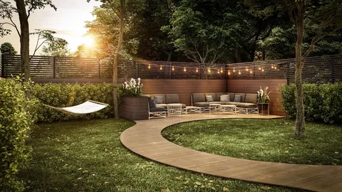
Landscape Rendering is a process that offers more than just mere visuals of an external environment. Typically, it is believed that this method is used for digitally developing the external environment of a residential or commercial building. Although it can efficiently do that, it can also be used for other purposes.
Among these various purposes, this article will explore how this technique can aid in accurately forecasting the environmental impact of construction. Besides this we will also discuss essential information regarding this innovative concept.
A Look Into Landscape Rendering
This rendering encompasses both two and three-dimensional techniques, which can accurately provide visual demonstrations for a conceptual landscape design.
In this process, extensive depictions are created of a landscape by capturing those details that matter. It includes vegetation or greenery, along with open spaces, and relevant environmental surroundings.
Landscape Visualization Platforms
The digital 3D platforms that provide landscape visuals of all aspects are:
- Lumion
- SketchUp
- Enscape
- Unreal Engine
- AutoCAD
- Maya
- Corona
- V-Ray
- 3Ds Max
Because of these digital platforms, Landscape Rendering Services have become more detailed and visually realistic. Thus, making a landscape design as close as possible to reality.
But how does this rendering aid you in predicting the impact of the environment before construction? Keep reading to know the answer!
Perception of Rendering from an Environmental Context
As mentioned above, this rendering is more than a visualization tool. This rendering is capable of merging 3D modeling with geographical information and specific environmental data. This merger allows professionals to develop precise visual depictions of a landscape.
Where conventional rendering technique only focuses on aesthetics and design, this rendering method helps you integrate essential environmental factors. Integration of these factors will help you predict the impact of the environment before construction is commenced.
Foremost Environmental Factors Assessed Through Rendering
Mentioned below are the key environmental factors that are efficiently dealt with this rendering method.
-
Topographical 3D Modeling
This rendering enables experts to create terrain models digitally. With these models, renderers can simulate how construction can change the flow of water. Because of these simulations, experts can analyze construction elevation data and predict in which areas water will accumulate.
This analysis will help them to include rectified measures, such as absorptive surfaces, before construction is started. Thus, ensuring that we prevent any rework at later stages.
-
Reducing Heat Island Effect
Global warming is one of the biggest concerns, and with this rendering technique, it can be greatly reduced. With digital modeling, the right materials and green elements are incorporated in a rendering.
The right material will efficiently reflect heat, while green elements will absorb it. Thus, it reduces the urban heat island effect to a great extent.
-
Building’s Orientation
Rendering platforms used in this method enable to simulation of how a building’s structure will cast a shadow during the day. This simulation will help in determining the orientation of a building for renewable energy installation, such as solar panels.
-
Climate Data Integration
Because of this rendering technique and tools used for it, climate data can be incorporated in a 3D model. This will provide the information regarding how construction will react to different climate conditions. Thus, enabling them to develop a more adaptable landscape design.
-
Lower Carbon Emissions
The carbon emissions of a landscape project can be assessed throughout its lifecycle by utilizing digital rendering platforms. This will greatly assist you in making more sustainable choices for your construction materials. On the other hand, it can also provide you with the long-term maintenance analysis of different materials. By reducing carbon emissions, you will have an environment friendly landscape construction project.
How to Deal with Rendering Limitations?
While this rendering can significantly help you in providing environmental forecasts, it also has some limitations. As renderings demonstrate what data has been input, this means that a rendering’s realism depends on the data.
Not only that, but dealing with the unpredictability of climate and other natural behavioral intricacies is another limitation. To deal with all of the above limitations and more, hiring the right professional is crucial.
Thus, you should go for SMA Archviz as your professional 3D Architectural Rendering Company for your landscape project. They are known for their ultra-realistic, detailed, and precise renderings.
Closing Thoughts
From the above discussion, there is no denying that Landscape Rendering has made a notable difference. This method has streamlined the entire rendering process, which has made the construction process more fluent, fast, and reliable. Furthermore, the tools used for this rendering efficiently help you in predicting how the environment will impact your construction. This allows you to adapt your processes accordingly for a better and definitive outcome.